Geo SubSea offers a wide range of services supporting freshwater and marine projects worldwide.
If we don’t have the expertise to assist you, we will find someone who can.
Services
Survey Support
Assisting teams around the globe
-

Geophysics
Strong familiarity with many different equipment manufacturers systems of side scan sonar, magnetometer, gradiometer, seismic reflection (chirp, pinger, boomer, sparker sound sources) and refraction (air gun sound source), as well as single and multibeam bathymetry echosounders.
-

Geotechnical
Geo SubSea is very familiar supporting geotechnical investigations that include all types of coring devices; field sampling via push, gravity, piston, vibratory, and electric corers, as well as jet probing.
-

Oceanographic
Deployment experience with a wide range of oceanographic and environmental sensors including ADCPs, tide and wave gauges, turbidity and water quality sondes; short to long term installations using satellite telemetered data back to the office.
-

Benthic
Geo SubSea has extensive experience mapping benthic habitats from initial sonar surveys recording acoustic reflectivity and backscatter to ground truthing via grab samplers, underwater video (cameras and ROVs), SPI (sediment profile imaging), and diving.
-

Positioning & Navigation
The company is familiar with a wide range of GPS solutions from DGPS to RTK for vessel and boat mounted transducers to USBL tracking for towed sensors and submersibles; all integrated into HYPACK/Qinsy for navigation and data logging.
-

Inspection
We have experience supporting the use of remote sensing and underwater camera systems for inspection of seafloor features, including ROVs, AUVs, underwater still and video cameras; work supports a wide range of tasks from search and recovery to benthic mapping to marine archaeology assessment.
“Jeff is a pleasure to work with and is at the top of my list of people that I recommend.”
Brayton Pointner, Owner & Operator, Theory Marine Services LLC.
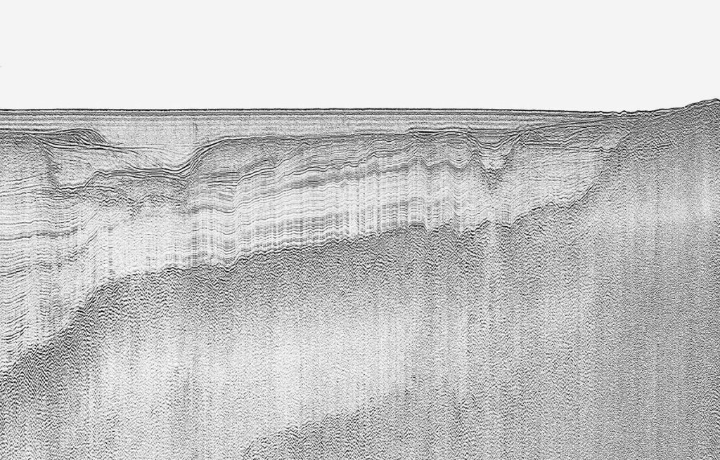
Data Processing
Geo SubSea can provide complete geophysical data processing capabilities with experience in these areas.
Side Scan Sonar
- Mosaicing, target picking, surficial sediment and features mapping
Magnetometer
- Contouring, anomaly picking, gradient mapping, residualization
Subbottom Profiling
- Reflector picking, seismic facies mapping, lithology determination, isopach development
Bathymetry
- Depth contouring, digital terrain modeling, feature mapping
…and we also have the ability to perform basic core sample processing for geotechnical programs.
Vibracores
- Core logging by a certified professional geologist, photography, subsampling
- Correlation of geotechnical data (cores, borings) with seismic profiles
Interpretation
Years of experience reviewing and interpreting seismic datasets makes Geo SubSea an authority on subsurface geologic mapping, with primary focus on high resolution mapping of the upper 500 ft of the stratigraphic column.
- Accurate, detailed analysis of lithologies represented on seismic profiles
- Development of subsurface geology models
- Assimilation of geotechnical data and results with seismic interpretations
- Expert knowledge of local stratigraphy via research and years of experience
Technical Document Preparation
We have extensive writing experience with the ability to present data, results, and concepts in a manner that is easily understood.
- Authored over 300 technical reports on projects worldwide
- Adept at presenting scientific data and results in clear, concise manner
- Excellent graphics production to illustrate data and results
Geo SubSea has provided professional reports supporting all types and phases of marine projects.
- Desktop studies
- Site and routing feasibility studies
- Technical, interpretative reports
- Environmental impact statements
- Government permit reports
Product Development
Geo SubSea has the ability to graphically represent geological data in map/chart form to effectively translate results to the client.
- Ability to provide scientific information clearly and concisely within a project budget
- AutoCAD and GIS experience for developing project drawings
- Proficient at the presentation of geologic data and results
- Can deliver digital products in a variety of formats to suit the client’s needs
Client Representation
Trustworthy Consulting to Minimize Your Project Risk
Personable and professional communication skills are combined with a thorough knowledge of the industry, government requirements, and construction–feasibility equating to minimal risk for your project.

Quality control for all phases of marine projects from scope development to field acquisition to reporting

Experienced project team member, great coordination and organization skills

Experience and familiarity with federal and state agency guidelines and permitting requirements

Knowledge and experience allows Jeff to serve as a subject matter expert (SME)
-

Project Management
Proven leadership in the field or office, using teamwork and initiative to achieve project objectives, all focused on providing results that exceed client expectations.
- 25+ years managing marine projects from contract award to final deliverables
- Effective team supervisor (field and office), working together to meet project goals
- Extreme project loyalty and adherence to deadlines
-

General Consulting
Strong attention to detail in all aspects of the company business and a passion for continuous improvement, sharing of ideas, and development of healthy, long term client relationships.
- Overall highly proficient marine scientific support
- Professional geology certifications, more frequently required on projects
- Excellent communication skills, build great relationships with clients